Site Characteristics
Existing Topography
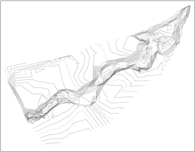
To acquire topographic data, measurements were taken using GPS and Total Station surveying equipment. Measurements of 37 cross sections for the reference reach and 61 cross sections for the existing channel were taken to determine the width and depth of the channel. Data was recorded with the GPS receiver as the surveyor moved downstream from the reference reach to the culvert going under Highway 180. In areas with thick tree cover, the GPS could not read data, so the Total Station was used. At each cross section, measurements were taken across the width of the channel from right over bank to left over bank. After recording the data for one cross section, the team used a 100-ft chain to measure the channel bed, right overbank and left overbank distances between cross sections.
Due to the intensity annual flood events, many alluvial deposits and scour zones are found at the project site along lower Shultz Creek. From the sieve analysis findings, it was found that fine particle sizes are present throughout the entire site. Due to the fine sediment existing at the site, the geomorphology of the stream corridor is highly dynamic. The historic flood plane has been abandoned and a lower flood plane has been established. Shown below is the existing site topography. The newly entrenched floodplain has created unstable levees with a high risk of bank failure.

Figure 1: Existing Topography
Existing Hydrology
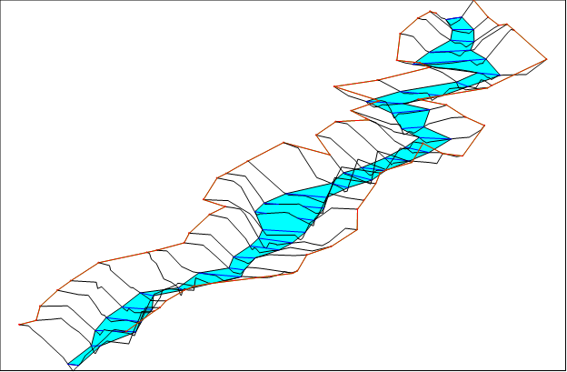
The existing hydrology was modeled in HEC-RAS, a one dimensional river analysis system (RAS). Shown below are the graphical interpretations of the existing hydrology during a 100-year flood event. The measurements obtained from the survey were used to determine the width to depth ratio, the slope gradient, and entrenchment, in order to determine the classification of the channel. Rosgen classification codes used in this section are found in the reference reach section.
Based on data obtained from the topographic survey, channel elevation and width were used to graph the bed line. Models were created in AutoCAD Civil 3D and HEC-RAS to determine the width to depth ratio, which is the width divided by the depth. The data collected measuring the thalweg is used to determine the slope of the stream by dividing the length of the reach by the elevation of the bed line. The figures provided beloware used to display the view of the stream channel looking upstream and from a profile view. From the data collected, there were six major reaches along the reference reach and seven major reaches along the existing channel.

Figure 2: Existing Hydrology
Watershed Delineation
Watershed delineations provide estimates for flow into a body of water or a channel. Watershed delineations can be performed manually or electronically using a USGS quadrangle topographic map. Performing a watershed delineation defines the area in which all precipitation and surface runoff is directed to the channel or body of interest. The watershed delineation for the Schultz Creek Restoration project site was performed using ArcGIS 10.2, which is an application used for collecting, managing, organizing, distributing, and analyzing geographic data from around the world. The complete watershed delineation of the Schultz Creek Project Site using ArcGIS 10.2 is illustrated below. The completed watershed delineation helped determine the following site parameters:
- Watershed Area ≈ 7,084 Acres ≈ 308,580,000 ft2
- Annual Flow = Annual Precipitation x Watershed Area = (22.8 in./yr). x (1 ft./12in.) x 308,580,000 ft2 = 586,302,000 ft3/yr
- Average Flow = 18.59 cfs
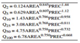
Using the information above and USGS stream flow regression equations shown below, flow for major flood events can be calculated, as shown below.

Figure 1: USGS Stream Flow Regression Equations
In the above equations, area is in units of square miles and precipitation is in inches per year. Using the regression equations, the 100-year flood event can be estimated to have a flow of 63 cfs. The values above take evapotranspiration and groundwater recharge into consideration, based on climate and elevation. The Schultz Creek Project site is considered to be in a high elevation zone.

Figure 2: Watershed Delineation from ArcGIS-10.2
